Quick Facts
Name
National Battlefields Park, also known as The Plains of Abraham National Park
Type of Landscape
Cultural Landscape
National Heritage Park: Canada
Location
Quebec City, QC
46°47′59″N 71°13′15″W
Designation
World Heritage City (UNESCO): 1985
Stewards
The National Battlefields Commission, Government of Canada
Legacy
Master Planning/Design: Heritage
Recreation and Well-Being
.png)
Introduction
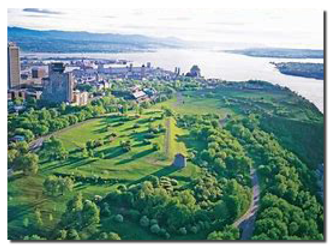
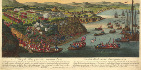
The Plains of Abraham National Park sits as a ship’s prow on the summit of Cap Diamant where the promontory’s steep slopes fall to the confluence of the St. Charles and St. Lawrence Rivers far below. The site is one of the most iconic in Canada, a unique combination of the forces of nature and culture. It is on this site that two great nations sought control of the northern territories of the New World. In 1759, the British army led by General Wolfe surprised and conquered the French forces led by General Montcalm in the battle that determined much of the history of the emerging nation of Canada.
A century and a half later, for the 1908 tricentennial of Quebec City, the newly formed National Battlefields Commission developed an urban park to commemorate the site.
For landscape architect Frederick G. Todd, assigned to develop a park plan and supervise its implementation, there was inspiration aplenty in “the grandeur of the views,” and the history of “these old fields of strife, now so peaceful.” The question was how to proceed – to retain the essence of the landscape at the time of the battle.
Todd’s plan skillfully integrated the parklands into the urban fabric of the upper city, detailing the shape and nature of five key areas. He took great care with its eight driveways and several entrances, its open landscapes and the siting of monuments and two Martello towers, all the while devoting considerable attention to the planting of trees. Formal street tree plantings line the entries to the site and the cross-axis of the Grande Allée, reaching out to the Parc des Braves as an integral component of the historic narrative. Large fields are bounded by rows of trees that meld into the heavily wooded areas on the steep slopes of the parkland.
Todd’s park is a conservatory of natural and cultural history of the place and its peoples, and the river landscape below.
Todd's Way
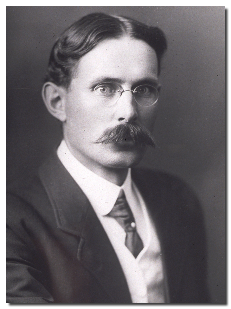
Frederick Todd arrived in Montreal, Quebec in 1900. He was a young apprentice sent to Canada by the renowned Massachusetts firm of Olmsted, Olmsted, and Eliot to work on the look-out of Mont Royal Park, designed by Fredrick Law Olmsted twenty-five years before.
He quickly established residency and a professional office in Montreal, and by the time he was commissioned to work on the Battlefields Park he had either initiated or completed a comprehensive plan for improving and beautifying Canada’s capital city (1902), the plan for Assiniboine Park in Winnipeg (1904-06), and the design and planting of Wascana Park in Regina (1906-08).
By 1909, however, Frederick Todd had re-defined his professional role. Todd resigned his membership in the American Society of Landscape Architects (ASLA). He now believed, contrary to the by-laws of the ASLA, that he should be involved in the implementation process as well. Consequently, Todd supervised the construction of the parkland project, supervising the costs, the labour, the technical requirements of grading and planting, and the detailed siting of monuments.
Over time, the Plains of Abraham Park proved a popular focus for the population of Quebec City and an important tourist attraction as well. Not surprisingly a number of changes to the initial project occurred in the ensuing years as the needs and desires of the population evolved. By 1931, the Park had added an underground urban reservoir, a multi-use trail for pedestrians and cyclists weaving its way through the steep slopes, and automobile access from the lower city (1931) by way of the Gilmour Hill road. By 1938, renowned Quebec landscape architect Louis Perron had designed the graciously formal Joan of Arc Garden. The garden structure reflects the French landscape tradition, while the planting reprises the British flower beds most famously associated with the influential British horticulturist and garden designer Gertrude Jekyll.
Landscape restoration has often been necessary: the park hosts ever-larger-scale celebrations on its historic grounds. Yet throughout its history, Battlefields Park has retained its openness and grandeur, its respectful care for its historic monuments, sustaining the visual integrity of Frederick Todd’s plan.
Today, a bust of Frederick Todd graces the landscape, erected in 2008 by the National Battlefields Commission, in celebration of Quebec City’s 400th anniversary. In addition, the Historic Sites and Monuments Board of Canada and Parks Canada designated Frederick Gage Todd as a National Historic Person in 2020.
A Conservatory of a Place and its People
The Plains of Abraham Park is a source of immense pride to Quebec City, a welcoming open space in an increasingly dense urban fabric, a major tourist attraction, a symbolic, almost sacred space in Quebec’s cultural ecosystem.
 Todd created a park very much in the spirit of the early twentieth century central parks that emerged throughout North America. The Plains of Abraham serve as the green lungs of the urban core of Quebec City. The heavily treed slopes and numerous wooded areas on the plateau shelter 90 different species of some 6,000 trees. Since its inception, thousands of annuals, biennials, and perennials, displayed in strategic corners and along heavily traveled paths, have all been grown and nurtured in greenhouses on the site.
The cachet of the parkland landscape is an immensely powerful tourist magnet admired for its flowing and varied vistas, the strategically located monuments, and the careful conservation of its military heritage. Today, The Park welcomes over four million visitors a year with activities organized in all four seasons, at day and at night. In winter, visitors explore groomed cross-country skiing trails, all manner of walking paths, two winter sliding trails, and a skating rink. By night, an intimate warming center is lit with 850 solar lanterns suspended in the branches of the elm trees.
In sharp contrast, in the summer a dizzying variety of cultural activities center on the Edwin-Belanger bandstand, treasure hunts are organized on the grounds, and exhibitions held within the Plains of Abraham Museum that features historical and archeological exhibits. Thousands and thousands of people flood the plains when the park hosts major community celebrations such as Quebec’s summer festival and the St. Jean Baptiste national festival. A network of paths, rest areas, and interpretive panels explore the natural and cultural history of the site while military parades in historical dress take place in the shadow of the Martello towers.
Yet it was Todd’s 1909 planning that set key boundaries: Maintaining the visual integrity of the plan, the sense of openness and grandeur of the parklands, and visitor attention on the monuments and historic structures that punctuate the landscape will continue well into the future. Frederick Todd’s plan and the National Battlefields Commission’s continuing commitment to its conservation constitutes an exemplary model of sustainable landscape design and management.


The Cultural Landscapes Legacy Collection highlights the achievements that have made a lasting impact within the field of landscape architecture and on communities across Canada.